We are excited to talk with you about ArcGIS Knowledge at the Esri User Conference this summer! Come see the new Knowledge Studio web application just released along with other updates that improve web map integration and time-based analyses. And hear about our plans for the AI Graph Query Assistant on the way!
The Esri User Conference (UC) is one of the best opportunities we have to hear from you. Come talk to us about how this ArcGIS Enterprise capability extension is helping your organization connect, analyze and visualize large amounts of structured and unstructured data together within spatial knowledge graphs. We want to hear how else we can help expedite your workflows and decision making.
So pencil in time for one of our technical sessions or to talk to our product experts on the Expo floor. Or simply reach out to schedule a 1 on 1!

Technical Sessions
These ArcGIS Knowledge sessions are specifically dedicated to ArcGIS Knowledge and led by product team members.
- ArcGIS Knowledge: An Overview (2 Sessions offered, 1 hour each)
Great for the curious and those getting started with knowledge graphs and graph analytics - ArcGIS Knowledge: Analysis Use Cases with Knowledge Graphs (45 min)
See a variety of use cases and learn about different patterns for working with graph analytics to complement and enhance spatial analytics to support intelligence production, criminal investigations, supply chain risk mitigation, asset management and more… - ArcGIS Knowledge: Data Integration Using Graphs (20 min)
Get a quick, focused overview of the different ways to load and manage data in your knowledge graphs and work with existing graph databases
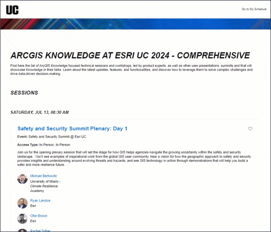
For the who, when, where, and what details for these dedicated Knowledge sessions, ✨ open this custom UC agenda ✨.
Just login to the UC conference page to add them to your own schedule and then access in San Diego using the free Events application.
For the Public Safety & Intelligence Communities
If you are joining us at the Safety and Security Summit July 13-14 at the Hilton Ballroom, be sure to look out for the following demos and sessions:
- Safety and Security Summit Plenary: Day 1
In part of this on-stage demo by Esri’s Ollie Brown, Knowledge will help discover and prioritize key meetings of interest using the Find Path tool to help accelerate intelligence production and mitigate uncertainty in the National Security space. - Integrating Graph and Spatial Analytics to Support Investigations (15 min)
In this overview, explore the expansive link analysis capabilities to explore a criminal network, linking together gang members by their vehicles mentioned in case reports
And later in the week, check out:
- ArcGIS AllSource and ArcGIS Knowledge: Investigating Illicit Activity (45 min)
See how ArcGIS Knowledge can help enhance investigations in the ArcGIS AllSource desktop tool to explore the Black Tulip Criminal Network, find persons of interest and use related motion video. - Object-Based Analysis in ArcGIS Using Activity-Based Intelligence (1 hr)
A GIS is the ideal system to analyze and exploit movement data. Whether your data comes from cell phone positions, GPS tags, or even artificial intelligence (AI) detections from video, ArcGIS provides a robust and flexible suite of tools that enables actionable analysis at any scale. In this workshop, learn how ArcGIS is used to solve your activity-based intelligence problems by characterizing activity, feeding your collections cycle, and share live results on both the desktop and the web. - Exploring Spatial Relationships for Intelligence Operations (1 hr)
With the abundance of data available to today’s intelligence analysts, synthesizing information and extracting relevant content is complex. The ArcGIS system includes applications designed to support intelligence operations and give analysts a competitive advantage by analyzing and visualizing data in new and compelling ways. In this session, you will learn how to use tools such as ArcGIS Knowledge and ArcGIS AllSource to conduct investigative, geospatial, and link analysis with real-world datasets.
Other Highlights Featuring Graph
- Spatial Analytics Summit
In this lineup of all-things-analytics, be on the lookout for Esri’s Amy Clarke and her powerful maritime intelligence demonstration, leveraging ship movement analyses tools and ship social network analysis featuring the new ArcGIS Knowledge Studio web application. - Exploring geologic-basin amplification of earthquake shaking using ArcGIS (User Presentation)
Ken Rukstales of the US Geological Survey compares models of seismic shaking using spatial pattern analysis, machine learning, and knowledge graphs to explore the data.
Explore all sessions featuring ArcGIS Knowledge or graph analytics in the custom agenda linked below.
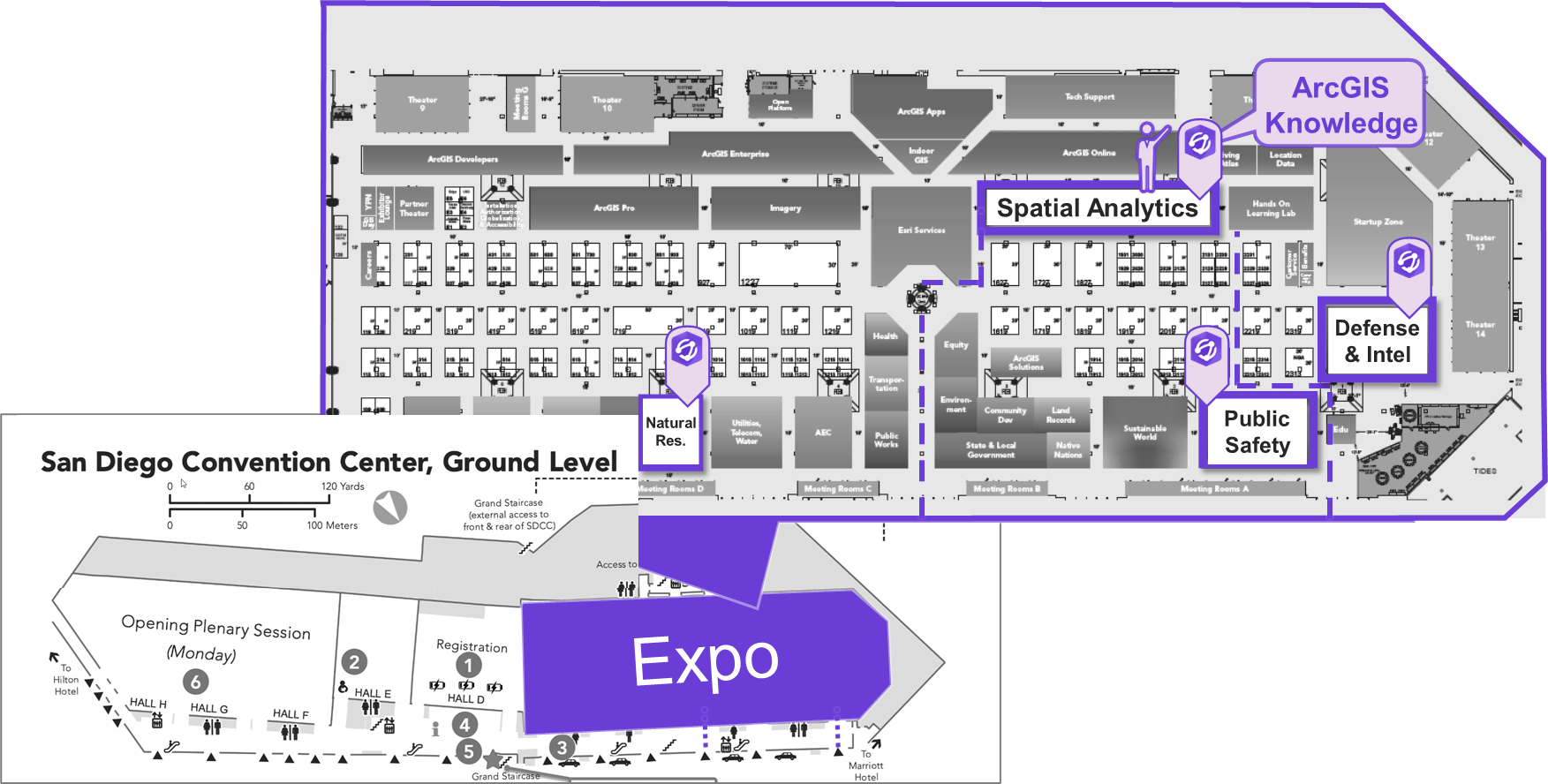
Drop by the Expo
Several product team members will be at our booth in the Spatial Analytics area during all Expo hours:
- Tue, July 16 | 09:00 a.m. – 06:00 p.m. PDT
- Wed, July 17 | 09:00 a.m. – 06:00 p.m. PDT
- Thu, July 18 | 09:00 a.m. – 04:00 p.m. PDT
Also on the Expo floor, we also have Solution Engineer specialists at the Public Safety, Defense and Intelligence, and Natural Resources industry booths with industry specific demos.
We hope to see you there!
Why ArcGIS Knowledge
Organizations work better when analysts and managers have immediate access to their data in full context. They can achieve this by bringing information about the people, places, sensors and concepts that matter together into a spatial knowledge graph, using spatial and logical relationships in a data model that is intuitive and in language of their business or mission.
By leveraging the combined power of spatial and graph analytics in spatial knowledge graphs, analysts can find hidden and important patterns in your data quickly. Using ArcGIS desktop applications, ArcGIS Knowledge Studio in the web and Knowledge APIs (REST, Python, JavaScript, .NET) your analysts, data scientists and data engineers can surface that key data quickly in full context to stakeholders and decision makers.
ArcGIS Knowledge extends ArcGIS Enterprise, enabling advanced data investigations and collaboration through spatial knowledge graphs.
Getting Started
Check out these resources to learn up before UC!
- Graph Analytics Webinar for Public Safety
- Technical sessions and demo videos from previous conferences
- Training Options (Self Service and Instructor-Led)
- Join the Esri Community and find more resources
- Q2 2024 Latest ArcGIS Knowledge Release Blog
Not at UC but have a question? Email us at AskArcGISKnowledge @ esri [dot] com

Article Discussion: