In Fast-Growing Spanish Fork, Utah, Field Crews Now Use UtiliSync to Complete Inspections
The City of Spanish Fork has always strived to be at the forefront of GIS in the state of Utah.
In 1995, the city invested in GIS to better manage how it did business. However, while this GIS-centric approach was quickly adopted in the office, field personnel were slow to embrace it. So although Spanish Fork was able to enjoy some of the benefits of GIS, it was still heavily dependent on paper-based inspections and other forms, which perpetuated inefficiencies.
One area in which the city really struggled was keeping track of the various reviews that need to be done for new developments. To be truly GIS-centric, officials at Spanish Fork knew they needed to find a way to get field crews and inspectors to enter data in real time while out in the field. For this, they turned to UtiliSync, which helps organizations automate their workflows with GIS-based mobile forms.
An Inefficient, Paper-Based System
“Here at Spanish Fork City, we are growing at an extremely fast rate,” said Travis Warren, the city surveyor.
But when it came to reviewing proposals for new developments, the process was quite disorganized. As with most cities, developers in Spanish Fork have to submit plans for various reviews—the preliminary plat review, the final plat review, and the site plan approval, for instance. This requires evaluations from multiple city departments.
Additionally, once a development is approved, office staff and field crews need to be able to communicate throughout the various stages of construction, from the preconstruction meeting to daily inspections to the final walk-through. City-based field crews are also responsible for keeping track of the time they spend on a particular job, since the city bills the developer for those hours.
But all this information was being recorded on paper. Oftentimes, when inspectors would go to start a new inspection, the stacks of paper would get swapped, and they would end up using old data instead of the most recent results. Sometimes corrections were made to an old report, but inspectors weren’t informed. So they relied on contractors to follow them around and keep track of areas that had been surveyed and inspected.
The GIS team suffered, too. Each December, the utilities departments used to drop off huge stacks of paper with more than a month’s worth of data in them, which staff had to enter into ArcGIS Desktop and map before the end of the year.
“It made it miserable trying to get all that paper work input in such a short time frame so that we would be ready for year-end reports,” said Shawn Beecher, the GIS administrator for Spanish Fork.
It was also difficult to keep the city council, the building department, and the city manager up-to-date with the latest information.
So Spanish Fork decided to digitize its workflows. The city looked first for an asset management program but found out quickly that it could use its existing GIS infrastructure to collect inspection information right in the field—at no additional cost. With Collector for ArcGIS, inspectors could gather field data directly in the city’s geodatabase using maps created in ArcGIS Online. This was big because it would allow Spanish Fork to set it up so that field crews could see the work they’d done the very next day.
The GIS department then found out about UtiliSync, available for use via ArcGIS Marketplace. UtiliSync takes a GIS-centric approach to document management by allowing users to attach custom forms to their GIS features. It can then turn these forms into PDFs and automatically distribute them to anyone who needs them.
“UtiliSync forms have allowed us to fully automate our inspection process,” said Warren. “This gives management, developers, and contractors real-time updates as inspections are completed.”
“Moving completely digital with ArcGIS Online, Collector for ArcGIS, and UtiliSync has made it so that information is more accurate, more easily accessible, and more up-to-date,” added Beecher. “There is no more waiting to get the information that the various departments throughout the city need [so we can] make more informed decisions.”
A New Way to Track Tasks
For development reviews, field crews now document all the work they do using UtiliSync.
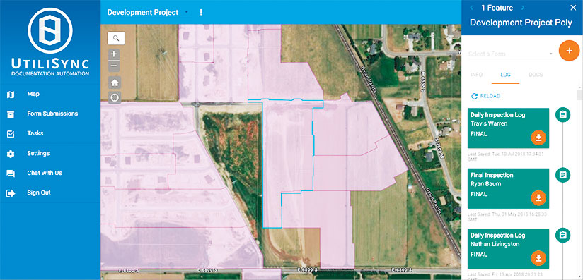
To get the process started, the city’s GIS department uses ArcGIS Desktop to create a polygon or polyline for each construction project. Field crews, office staff, and anyone else that has access to this data can now edit directly in the database. And all of it is immediately viewable in UtiliSync.
From there, users can tap on a GIS feature in UtiliSync and complete one of the many smart forms attached to it, including plat reviews and daily inspection forms. Once a form is filled out, UtiliSync automatically creates a PDF of it, saves it to an archive, emails it to a dynamic list of recipients, creates a related record in the GIS database, and updates the GIS attribute in Spanish Fork’s enterprise geodatabase.
By using UtiliSync’s smart forms, field inspectors can focus on their evaluations. They don’t have to do anything extra to make or distribute a PDF of their work, and they know that the GIS attributes will be updated promptly.
“UtiliSync [enables] us to track our daily tasks with an easy-to-use, map-based interface while allowing us to store and edit the data in our geodatabase, [which] is being consumed by ArcGIS Online via our services in ArcGIS Server,” explained Warren.
Furthermore, with all the inspection data stored in Spanish Fork’s ArcGIS Online account, city managers and department heads are able to use Operations Dashboard for ArcGIS to track the progress of development reviews. They can see, among other things, how many hours inspectors have logged for the current month and where they have conducted inspections.
More Consistent, Accurate Information
With UtiliSync, all stakeholders for a new development—from administrators, inspectors, building crews, and city council members to citizens, investors, and store owners—are able to view the up-to-date status for any development project in Spanish Fork. The information is more consistent than it used to be, and nobody has to waste time tracking down a specific inspector to get the current paper work from his or her truck.
“The accuracy of the information gathered increased exponentially,” said Warren. “All data from in-house, as well as outside contracts, is stored in one location.”
No more scrolling through lists or shuffling through stacks of printouts to find the right development. Inspectors can conduct their reviews at the correct locations, despite often receiving inaccurate addresses, since development projects tend to have unassigned street numbers on unnamed streets. Rather, they can find a specific development on a map and know exactly where it is.
Moving completely digital with ArcGIS Online, Collector for ArcGIS, and UtiliSync has made it so that information is more accurate, more easily accessible, and more up-to-date.
Additionally, building inspectors can view final checklists for a development review just by clicking on a particular development on the public-facing web map hosted on the city’s website. This allows them to easily update contractors on their projects and inform owners of when they can take possession of their buildings.
And in the two years since the city started having field crews use UtiliSync to report the hours they work at each site, Spanish Fork has experienced a 187 percent increase in inspection fees. This is because the city can now accurately track the time its field crews spend on specific projects, according to Warren.
“UtiliSync has been an essential tool in our time-management and inspection processes,” he concluded.
For more information about UtiliSync, head to ArcGIS Marketplace or email UtiliSync founder Matt Stayner at mstayner@utilisync.com. For more information about how Spanish Fork integrates all its GIS and UtiliSync technology, email Shawn Beecher at sbeecher@spanishfork.org.